

TRANSPORTATION
Active Transportation

October 18, 2023
When: 12PM
Where: Lehigh Valley
Planning Commission
November 15, 2023
When: 11AM
Where: Lehigh Valley
Planning Commission
December 20, 2023
When: 11AM
Where: Lehigh Valley
Planning Commission
The Lehigh Valley Planning Commission has received $1 million in planning grant funding from the U.S. Environmental Protection Agency (EPA) through its Climate Pollution Reduction Grant (CPRG) funding program. This CPRG funding opportunity provides resources to eligible Metropolitan Planning Organizations to develop and implement plans for reducing greenhouse gas emissions and other harmful air pollutants. The $1 million will be used over a four-year period, with the first step focused on developing a Priority Climate Action Plan for the Lehigh Valley, which will be due on March 1, 2024, and will focus on Transportation Decarbonization.
The focus on emissions associated with transportation is an important focus due to an increasingly large portion of our regional greenhouse gas emissions are from this sector. Please join us for our upcoming WorkshopLV: Environment – Transportation Decarbonization (Priority Climate Action Plan) series. This workshop series will be held within LVTS, Environment Committee, and Transportation Committee virtual monthly meetings to provide further information on the CPRG grant, present an updated greenhouse gas inventory for the transportation sector, discuss the priority climate plan focused on transportation decarbonization as well as hear your input about the plan.
PAST MEETINGS
September 20, 2023
9AM
LVTS Meeting
VIEW MINUTES
October 18, 2023
12PM
LVPC Office
September 27, 2023
12PM
Environment Committee Meeting
VIEW MINUTES
November 15, 2023
When: 11AM
Where: Lehigh Valley
Planning Commission


April 21, 2023
12PM - 1PM
Virtual Meeting
With aggressive driving on the rise and pedestrian safety at risk, the LVPC and Lehigh Valley Transportation Study are scheduling a special WorkshopLV: Multimodal virtual session to give our municipal partners and communities leaders the latest on what’s being done right now to improve pedestrian safety and where to find grants to help make all of our communities safer and more walkable.
WorkshopLV Multimodal: Pedestrian Safety will cover the funding focus of the Bipartisan Infrastructure Law, a new Walk Audit program about to start regionwide and several grants opportunities that can benefit every community.

The LVPC and LVTS has adopted the plan that coordinates transit, trail, sidewalk, bikeway and roadway systems to create a robust regional transportation network that is safe, convenient and efficiently accommodates bicycle and pedestrian transportation. The interconnection of these transportation systems for a seamless walking, bicycling, safe routes to transit system that combines the on- and off-road network supports larger regional goals of sustainability, resiliency and enhanced livability.
Community Design Projects

BATH MULTIMODAL SAFETY + PARKING ANALYSIS
SUMMARY
Bath is a borough of 2,700 people that has an attractive setting in Northampton County and an historic charm that’s helped its downtown withstand economic downtowns. However, its location at the intersection of five busy state roads makes it particularly vulnerable to the kinds of challenges that can come from growth, congestion and truck traffic. The demand on the street network, combined with a lack of cohesion in policies that don’t always promote safe connectivity for drivers or pedestrians, hasn’t maximized positive growth or highlighted the special historic character of the Borough. The size of Bath, its commercial zoning opportunities and proximity to a growing trail network however, make it an ideal candidate for installing active transportation improvements. Through partnership with the Lehigh Valley Transportation Study, Borough of Bath and Pennsylvania Department of Transportation, a year-long study was initiated in December 2016 to determine what those improvements could be.
The study began with the collection of information including vehicle volumes, parking capacity, safety data and projected road work in order to identify problems affecting efficiency and safety within the borough's transportation network. During this phase, three project goals were established:
Safety for all users
Adequate parking + connectivity
Preparation for future growth of the borough
A second phase of the project used that information to develop appropriate and realistic recommendations for a cohesive, long-range strategy of street network improvements. These place heavy emphasis on encouraging walkability, multimodalism and placemaking in the central blocks of the commercial and historic district. The report and its recommendations were adopted by Bath Council in July 2018.
Click here to view the full report
The project is already making news. Click here to view the May 7, 2018 LVB.com article "Strategies for upgrading Bath's downtown core revealed"
IMAGES OF BATH BOROUGH AND CONCEPTUAL RENDERINGS
The renderings below demonstrate how, through coordinated efforts by various stakeholders, Bath Borough's street networks might better function for drivers, pedestrians, bikers, residents and business owners.


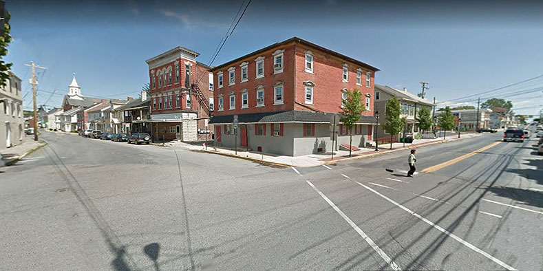
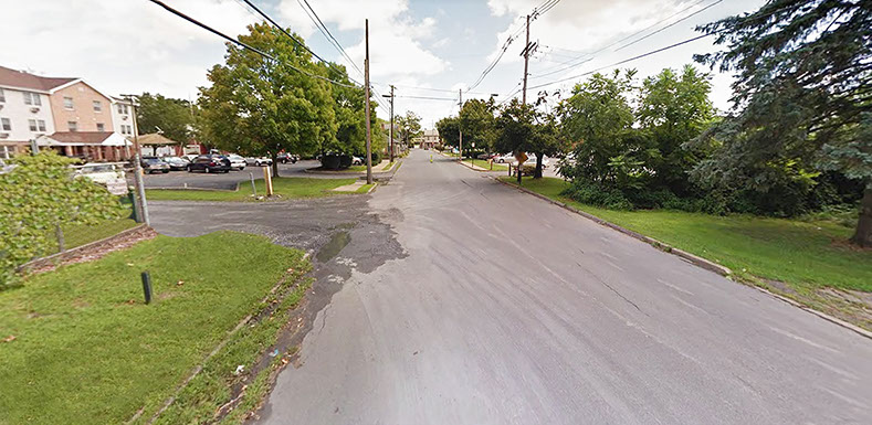
This intersection of West Main Street + South Chestnut Street currently lacks clarity. Striping for pedestrian crossings are almost non-existent, parking spaces are not striped and, in spite of the special historic character of the buildings, there is a lack of sense of arrival or historic pride. Also, the wide turning radius does not encourage drivers to reduce speed.
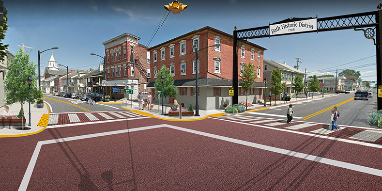
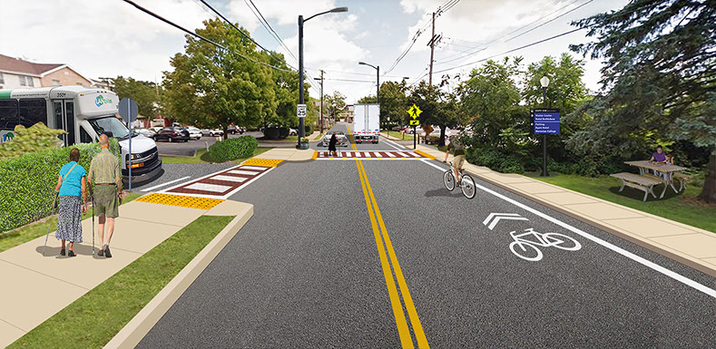
This visualization shows clear and vivid street markings which, especially from a distance, indicate that vehicle drivers should approach the intersection with caution. Increased lighting, landscaping treatments, and shared lane bicycle markings encourage other modes of transportation. A gateway sign shows a sense of arrival and local pride.
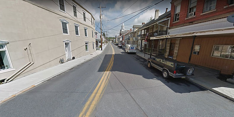
This view looking north on South Chestnut Street shows a road lacking in lighting, clear curb markings or parking spaces, and a general lack of features to help tie together the elements that give it unique character. This road section is also notorious for vehicles speeding through.
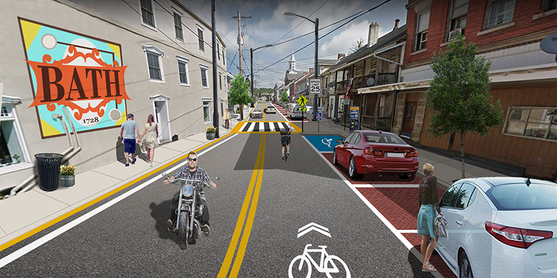
This visualization shows a series of improvements including clear road markings and a striped crosswalk which should slow vehicles down while also encouraging pedestrian and cyclist interaction. Increased lighting, small landscape features and a wall mural contribute to beautification of the street.
This view looking east on Mill Street shows a lack of consistency. The widest road in the study area, its sidewalks have only been partially completed and there is an informal pedestrian crossing that is easy to overlook. Stormwater has taken a toll along parts of the edge of the road and there is a lack of lighting.
This visualization shows the street's potential as a vital and welcoming link for pedestrians and cyclists who will access the borough from the future connected Nor-Bath Trail. Completed sidewalks and formal pedestrian crossings increase safety. A historic marker sign reinforces the historic value of various points in the borough.
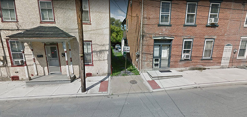
Although this space in between these two buildings is small and without defined purpose, it could still host a variety of features that engage passerby and increase the street's vitality.
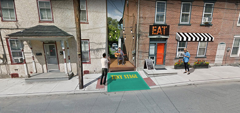
This visualization shows an example of "creative placemaking" which is the creative designing of particular public spaces by the people who use them. This tiny stage option would be very low-cost, could be flexible in its functions and "adopted" by local artist organizations or student groups, for example.
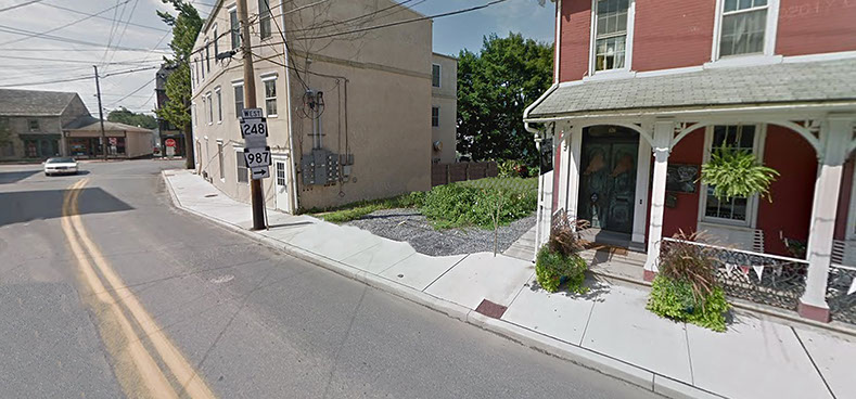
This is another example of an in-between space that could offer a more engaging experience.
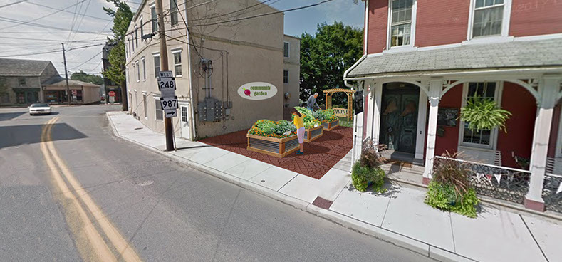
This visualization shows that a large space isn't needed to serve a useful function in a community. This garden could reinforce the values of local food production which are already established at the Bath farmer's market and act as a hands-on learning space. It's maintenance would also encourage a sense of pride and stewardship.
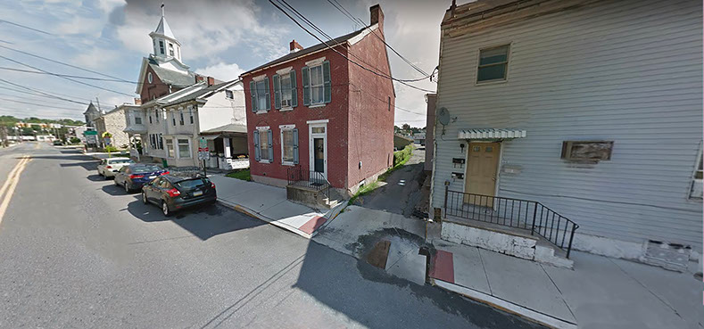
This is an example of a space which currently functions as an alleyway for a small amount of vehicles and how it could be converted into a more interactive place.
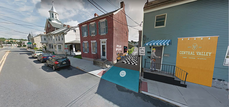
This visualization demonstrates a simple idea for engaging young people as there are no play areas along this stretch of road. One of the previous two entrances to the alley would be blocked to vehicles and function as an informal play place with a large-scale chessboard, chalkboard and hopscotch.
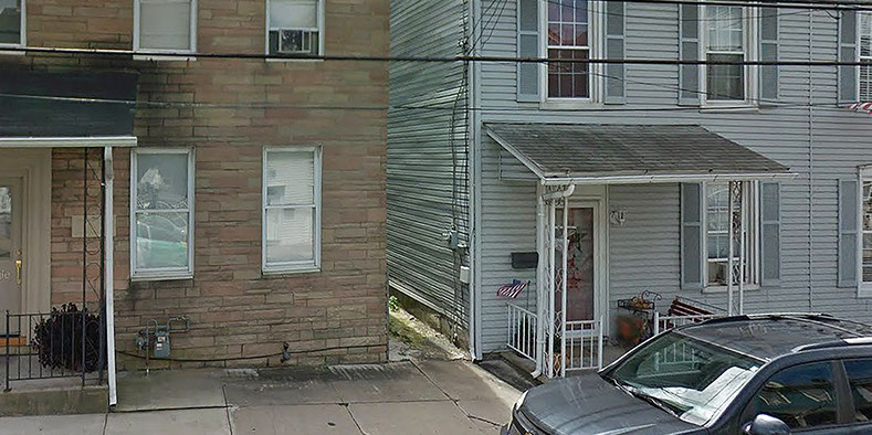
This in-between space is only a few feet wide however still has an opportunity of bringing something special to the street.
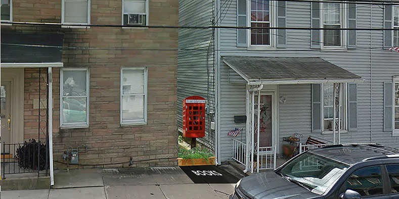
This tiny library, as in many other places around the world, could be an attraction or pedestrian stopping point for people who want to leave a book or borrow a book. As the borough doesn't currently have its own library, it could serve as a mini-destination for families or school children and generally demonstrate support of local or national reading programs.
7 - 14
<
>
CATASAUQUA FRONT STREET STUDY

Sidewalk Inventory

WALKLV
This sidewalk inventory is the first of its kind for the Lehigh Valley region and intends to provide an assessment of sidewalk
connectivity. Among the many beneficial applications to this study is one main goal: to promote an interconnected network of pedestrian-accessible transportation corridors.
Uses of the Inventory
The Lehigh Valley Planning Commission (LVPC) has analyzed the results of this inventory against both the transit stop inventory in an effort to identify significant gaps and the trail inventory to identify opportunities for future connectivity. Sidewalk gaps represent a significant barrier to accessibility, and this report will lay the groundwork for a future regional bicycle and pedestrian planning study, which municipalities can use to underpin a variety of additional multimodal activities. This study will support prioritization of projects; inform funding decisions; support comprehensive planning efforts; support bicycle and pedestrian; and parks, recreation and open space initiatives. The results are available to our state, regional and municipal partners, such as the Pennsylvania Department of Transportation, Lehigh and Northampton Transportation Authority (LANta), Lehigh Valley Greenways Conservation Landscape, health officials and school districts. In addition, the inventory will be readily available in an easy to access online format, which will serve as a tool for future planning and prioritization.
Trails Inventory
This 2013 update, in addition to incorporating updated trail information, includes two new components: identifying priority trail gaps and providing guidelines to designing safe road crossings for trails. These two new components are part of a statewide effort by the Department of Conservation and Natural Resources (DCNR) to help organizations and municipalities to implement trail initiatives. There is a lot of interest in trails in the Lehigh Valley, and hopefully this compilation of current trail efforts will provide municipalities, counties, and conservation partners a tool in advancing the development of the Lehigh Valley trail network.
Lehigh Valley Trails Inventory PDF
Street Connectivity Guidance Document
Connectivity is an analysis of the number and variety of connections serving origins such as residential
neighborhoods and destinations like schools and shopping areas. Connectivity relates to the number of intersections
along a segment of streets and how the entire area is connected to the system. Good street
connectivity means providing a variety of ways to get from Point A to B, from using the car to walking. The
recommendations in this report are geared toward improving the efficiency of mobility (i.e. ease of movement)
and accessibility (i.e. the ability to go from an origin to a desired destination). The benefits of better
connectivity go beyond improved mobility and accessibility and can include less traffic congestion, safer
streets, municipal cost savings in the provision of services, and reduced need to improve arterial streets.
Street Connectivity Document PDF
The LEHIGH VALLEY TRANSPORTATION STUDY (MPO) is committed to compliance with nondiscrimination requirements of civil rights statutes, executive orders, regulations and policies applicable to the programs and activities it administers. Accordingly, the MPO is dedicated to ensuring that program beneficiaries receive public participation opportunities without regard to race, color, national origin, sex, age, disability or economic status. Meeting facilities are accessible to persons with disabilities and the location is reachable by public transit. The MPO will provide auxiliary services for individuals with language, speech, sight or hearing impediments provided the request for assistance is made 14 days prior to the meeting. The MPO will attempt to satisfy other requests, as it is able. Please make your request for auxiliary services to planning@lvpc.org 610-264-4544. If you believe you have been denied participation opportunities, or otherwise discriminated against in relation to the programs or activities administered by the MPO, you may file a complaint using the procedures provided in our complaint process document or by contacting planning@lvpc.org or 610-264-4544.
El ESTUDIO DE TRANSPORTE DE LEHIGH VALLEY (Organización Metropolitana de Planificación [MPO, Metropolitan Planning Organization]) está comprometido con el cumplimiento de los requisitos de no discriminación de las leyes de derechos civiles, los decretos ejecutivos, los reglamentos y las políticas correspondientes a los programas y las actividades que administra. Por ende, la MPO se dedica a garantizar que los beneficiarios de un programa reciban oportunidades de participación pública sin tener en cuenta su raza, color, país de origen, sexo, edad, discapacidad o situación económica. Las instalaciones para reuniones son accesibles para las personas con discapacidades y se puede llegar a su ubicación usando el transporte público. La MPO brindará servicios auxiliares para personas con impedimentos lingüísticos o problemas de habla, vista o audición, siempre y cuando la solicitud de asistencia se haga 14 días antes de la reunión. La MPO intentará responder a otras solicitudes, según sus posibilidades. Solicite servicios auxiliares llamando a planning@lvpc.org o al 610-264-4544. Si cree que le negaron oportunidades de participación o que lo discriminaron de otra manera en relación con los programas o las actividades que administra la MPO, puede presentar una queja siguiendo los procedimientos que figuran en nuestro documento de proceso de queja o comunicándose con planning@lvpc.org or 610-264-4544.
Lehigh Valley Planning Commission
961 Marcon Boulevard - Suite 310
Allentown, PA 18109
Phone: (610) 264-4544
Toll Free: (888) 627-8808